|
Cotton Gin Port .. in its hey day. |
|
|
Road Signs home Mississippi
|
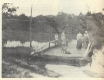
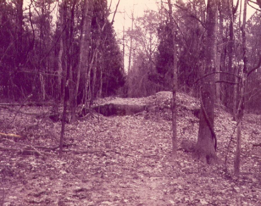 Remains of the pavement of Jackson Street, the main street of the town. The end of the street before the old bridge crossing the Tombigbee at Cotton Gin Port circa 1974 - Photo by Julia Wall
Cotton Gin Port’s hey-dayThe first white settlers began arriving at Cotton Gin Port in 1816, as soon as the land was ceded. When the first white settlers arrived in the area in the spring of 1816, the only resident of Cotton Gin Port was a Creek Indian named Billy. Five families came from Russelville, Alabama, to settle near Cotton Gin, led by Reverend Frederick Weaver. William Wise, John and Abraham Gideon and their families were the first of a wave of settlers eager to take advantage of the newly opened lands. Weaver settled on land one mile southeast of the Port on Weaver's Creek, where he built New Hope Church, the first church in northeast Mississippi. Wise and the Gideon brothers moved several miles northeast and began the Quincy settlements. Eli Thames and Robert Coil brought their families to the Port in 1817. Thames took over the ferry and opened the first blacksmith shop in that year. William Wise went back to Russelville and persuaded several families to return with him that same year. By 1820, there were enough people settled at Cotton Gin Port to call it an unorganized town. There were about eight log cabins at the site. Isaac Mayfield built the first large general store that year. Major Mayfield also opened the Cotton Gin Port Hotel about this time. James Ederington and Charles Hudspeth opened a trading post for the Indians as partners. Hudspeth built the first gin, excluding the ill‑fated Indian cotton gin, and Barney H. Flynn built the first grist mill, taking advantage of an artesian spring at the edge of the river bank.
|
|
Monroe County In 1821, Monroe County was formed. When the state line between Mississippi and Alabama was surveyed, the settlers realized that they actually lived in the state of Mississippi and not Alabama. Court was held in the village as early as 1821 before a seat of justice was established for newly formed Monroe county. The original county included all of Lowndes and most of Monroe east of the Tombigbee. At the time, there were 371 households along the Tombigbee, Buttahatchie, and Luxapalila. The formation of the new county touched off the “Courthouse Wars” that Evans writes of in Mother Monroe, with the county seat switching between Hamilton, then Athens, and only temporarily in Cotton Gin Port, before settling in Aberdeen. In 1824, the Cotton Gin Land Company was formed. Trustees of the company were: Brice Garner, Dan Burdett, Abner Pruitt, D. W. and W. H. Ragsdale, William Wall, John Kirk, and Benjamin Harris. In 1835, the Chickasaws ceded the remainder of their lands in Northeast Mississippi and were removed to Oklahoma, starting their “Trail of Tears” from Cotton Gin Port. “Tradition says the white settlers watched for three long days and nights while the mourning Indians passed through Cotton Gin Port on the first leg of their journey to Oklahoma,” wrote Miss Lucille Rogers. Another legend says that the Chickasaws hid or buried gold and other valuables in and around Cotton Gin Port before they left. One story tells of a dark skinned stranger who rode the freight rails to Amory in the 1920s, stayed in the black section of town and hired a colored man to drive him out to the port site in a wagon, then brought back an iron box which he stowed in a tow-sack. He then caught a freight train out of town and was never seen again. This story was told to me by my grandfather, Will Walls, who was the youngest son of Jesse Washington Wall, the last ferryman at Cotton Gin Port. The Walls family was living at Cotton Gin Port until some time after 1917, the year Jesse Wall died. My grandfather said, “I don’t know if that story is entirely true, or if it means any thing, but I saw the square shape of a box at the bottom of a hole they dug under one of those big old trees.” This conversation probably took place during a visit in December 1975. After the Chickasaws were relocated, the town relied heavily on the cotton trade and became a steamboat shipping point on the upper Tombigbee. The town, incorporated by the Mississippi Legislature in 1838, reached its most prosperous period around 1848. During the town's most prosperous decade, 1848 to 1860, there were five streets running east and west, most of them residential. Jackson Street was the main street terminating at the boat landing. Most stores were on the north side of Jackson facing a row of oaks. The saloon was on the eastern end of this street. Gaines Trace paralleled Jackson to the ferry landing. The southeastern section of the town was the residential district. The cemetery was located in this area where the old highway turned from southwest to west. The old grist mill, supplied by an artesian well, was located two hundred yards north of the line of oaks. In these prosperous years, Cotton Gin Port boasted five hundred inhabitants. There were a carding factory, a flour mill and sawmill, a blacksmith shop, a hotel, a cotton gin, a barbershop, a drugstore, a post office and twenty stores, one of which was a jewelry store owned by Robert Gordon who founded Aberdeen. Businesses prospered, offering "terms as liberal as any other a establishment in the South Country" as an 1836 advertisement for W. G. W. Jower's "new drug and Medical Store (one door east of Walton and Daggett's)" boasted. Besides drug and medical supplies the store carried "paints, oil, dye, perfumery, and fancy articles." The town had the best landing site along the northern Tombigbee. After 1836, rivertrade was the main livelihood of Cotton Gin Port. In the early 1820's the steamboats replaced the flatboats which could not navigate upstream. Before 1860, there were no railroads in Monroe or neighboring counties. The roads were in poor condition so stages were little competition. In 1822, the first steamboat, "Cotton Plant" under Captain Chandler, reached as high as the Port. Navigation on the upper Tombigbee was seasonal at best. During the winter when the river was high, steamboats could travel as high as Camargo on Town Creek or Fulton on the river. In the spring the river was lower, and the boats could get no higher than Columbus. Goods would then be freighted to Columbus on the Barton's Ferry Stageline. In peak seasons boats made two round trips per month. The steamboats carried cotton, furs, hides and beeswax, as well as passengers and mail. "New Iberia" was one such steamboat recorded as owned and operated out of Cotton Gin Port in 1836. Between 1850 and 1859, thirty‑nine steamboats, all sternwheelers due to the relatively narrow river, operated on the upper Tombigbee including: "Amarinth," "Jenny Lind," Duquesne," "Sunny South," and "Ariel." Occasionally these boats hauled loads of more than one thousand bales of cotton, according to John Rodabough, in Steamboats on the Upper Tombigbee. Cotton Gin Port was a noted social spot. Law enforcement was lax. There was no jail and only one church. The saloon did a thriving business. Brandy was made in the hills around Quincy and shipped to Aberdeen and Cotton Gin. Horse racing was popular in Monroe County, and Billy Wall ran the racetrack at Cotton Gin Port. The river front was bustling with planters shipping cotton out and boats coming up from Mobile and other ports with wares. Violence was not uncommon. The Port had long been a stopping place for adventurers, rowdies, and petty villains along the Trace. One of the South's most infamous desperadoes, noted for horse theft, robbery, and slave trade, John Murrel, is said to have hung out along Weaver's Creek. Twenty men were said to have belonged to Murrel's gang between 1826 and his capture in 1834, when he was turned in for the reward by one of his henchmen. Murrell considered himself quite the celebrity in prison. Another story about Cotton Gin Port is that it continued to flourish until the railroads put it out of business, but local historian John Rodabough, in Steamboats on the Upper Tombigbee, wrote that the town had not had much chance of success due to poor location in a swampy place subject to flooding, and better accommodations for steamboats in Aberdeen and other ports. The flood of 1848 did a lot of damage to the town. During the Civil War, Monroe County sent more men per capita than any other county in Mississippi. The damage to the economy and the loss of the need for shipping via steamboat pretty much ended prosperity for the Port. Cotton Gin Port died abruptly in 1887 when the Kansas City, Memphis and Birmingham railroad laid its tracks three miles to the east of the town. The railroad surveyed the lots and planned the town of Amory. The businesses and residents of Cotton Gin Port quickly relocated. According to legend, some of the buildings at Cotton Gin Port were disassembled and taken to Amory, while other smaller structures were rolled on logs intact to the new town. And so Cotton Gin Port literally disappeared essentially overnight. The ferry continued in use until an iron bridge was built across the river in 1914. Just before World War II, Hwy 278 was located about a mile north of the old port with a big new concrete bridge, then during the war effort the iron bridge was dismantled for scrap. The concrete pilings are still visible at the port site.
|
|
|
This is a blurred image of the ferry at Cotton Gin Port, which was in operation as early as 1803, and continued to operate until 1914 when an elaborate iron bridge was built across the Tombigbee River on the Cotton Gin Port – Okolona Road. This concreted road ran along what had once been Jackson Street, the main street of Cotton Gin Port in its hey-day. The fancy iron bridge was only in use for a few decades. In the late 1930s, Hwy. 278 was laid out about a mile north of the old bridge, and a new bridge was built across the Tombigbee there. Cotton Gin Port had been abandoned in 1887 when the Kansas City, Memphis and Birmingham laid its tracks 3 miles east of the port site. The railroad laid out a new town and sold lots for Amory, which was named for a railroad executive. Even though most of the businesses literally moved to the new town over night, leaving the port as practically a ghost town, the ferry remained. Hwy 278 effectively by-passed the Port site altogether. Always in a bad spot health wise, being located on a low bluff on the east bank of the river which was susceptible to flooding, once the new highway by-passed the site it fell into decay and overgrowth. River pilings still remain from the 1914 bridge that spanned the Tombigbee River at Cotton Gin Port. The concrete road that led to the bridge, called the old Cotton Gin Port – Okolona highway, ran along the main street of Cotton Gin Port – Jackson Street – although the town was abandoned long before the bridge was built.
|
|
|
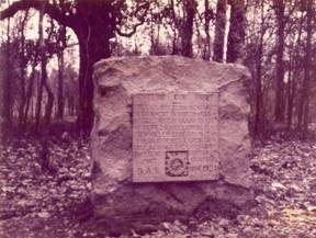
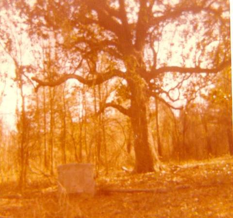
Finally in the mid-1970s the Tenn-Tom Waterway was constructed a few miles east of the Tombigbee River itself. That part of the Tombigbee was by-passed by the channel that runs in a straight path instead of the horseshoe bends of the port and ferry crossing. All that remains are historical markers... How could a once thriving town all but disappear? There are signs of the town: an historical marker on Hwy 278 and the D.A.R. marker under the magnolia at the port site. For all practical purposes, Cotton Gin Port is gone.
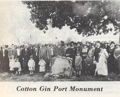
The DAR monument under the “Cotton Gin Port magnolia” – set up in 1924.
Cotton Gin Port furnished a point in time and place, a gateway for white settlement of Monroe County, but more importantly it became a focal point for the sense of identity of residents of Monroe County. Elliott writes that in 1876 at the celebration of the country’s centennial, Monroe County celebrated at Cotton Gin Port, even though Aberdeen was the country seat. Monroe County looked to the older port site and claimed it as their “point of origin.” Monroe County also pointed with pride to their Indian roots. The place names acknowledge our Chickasaw ancestors, and this was long before it became popular. The port symbolized a kind of “getting along” between the two cultures, too, because although the Chickasaw fought the Spanish and the French, they were allies of the English and then the Americans. Notice that in those legends, the Europeans were not the heroes of the story – the Chickasaw were. Even though the little town did not thrive long once the Chickasaw were relocated and other towns in Monroe County served the cotton planters better, it was still looked upon as the birthplace of Monroe County. The people defined themselves and their region from this one point on the Tombigbee River. |
|
|
The famed “Cotton Gin Port Magnolia” was said to have been brought by steamboat from Mobile and planted in the yard of one of Cotton Gin Port’s leading citizens, Peter Knowles. This is the location of the D.A.R. monument, which does look for all the world like a tombstone. Supposedly the monument was set up in 1924 (see newspaper clipping above). This old home was still standing in 1915. My great grandfather, Jessie Washington Wall, who was one of the last ferrymen at the Port, died in the old Knowles home in Cotton Gin Port in 1915. The old Mayfield Hotel was one of the last of the Cotton Gin Port buildings to be torn down. The building was torn down in the 1950s, and a cache of Confederate money was discovered hidden in the walls.
|
|
| <previous page |